Windham Life and Times – November 20, 2020

The Border Dispute

The Royal Border Settlement 1740-1 III

       Haverhill, Methuen, Dracut and Dunstable were all Massachusetts towns who claimed that their border lines travelled into southern New Hampshire until declared otherwise by the crown in 1741. William Harris who wrote a local column in the Exeter Newsletter in the late 19th and early 20th centuries wrote  about the border dispute between Massachusetts and New Hampshire:

     “In April 1719, a company of people from the vicinity of Londonderry, Ireland, commenced a settlement called Nutfield, having its center at what is now East Derry. They described themselves in their petition for a charter as ‘being descended from and professing the Faith and Principles of the Establist Church of North Britain’—that is, Scotch Presbyterians. Incorporation was at first denied by both New Hampshire and Massachusetts, as it was doubtful which province had jurisdiction.”

     “In October following, the settlers obtained title to their lands by deed from Col. John Wheelwright, of Wells, ME., whose grandfather, Rev. John Wheelwright, the founder of Exeter, was supposed to have purchased in 1629 from Passaconoway and other Indians chiefs a large tract of land between the Piscataqua and Merrimack Rivers. Colonel Wheelwright’s deed conveyed a tract not to exceeding ten miles square, bounded by the Merrimack River at the west and the lines of Dunstable, Dracut, Haverhill and Cheshire (Chester). The description reads as if the north boundary of Dracut met the west line of Haverhill but when Methuen was incorporated in 1725, it was made out of the western portion of Haverhill and a strip about one and a half miles wide of ‘country land’ of unincorporated land stretching north from the Merrimack River, between the limits of Haverhill and Dracut.”

     “June 21, 1722, the governor and court of New Hampshire gave a charter incorporating Nutfield as the town of Londonderry. Its boundaries began at the southeast corner of Chester (which town had been charted the moth previous) and ran definite distances in specified directions, not naming the Massachusetts towns of Haverhill, Dracut and Dunstable, merely providing that this grant should not annul any claim which the Province of Massachusetts Bay might have to any of the territory granted. It must have been known at the time that the boundaries as given, overlapped by a considerable space the limits claimed by all three towns. There was considerable controversy and litigation between Londonderry and Haverhill settlers over lands in the strip which both claimed, until 1740, the province boundary dispute was ended by the decision king that the line should be three miles north of the Merrimack River, which decision was effectual the next year by the actual running of the line, practically where it is now. A portion of the Londonderry grant would have indeed fallen within Massachusetts if the province line had been run straight west from a point three miles north of the mouth of the Merrimack, which was all that New Hampshire claimed.”

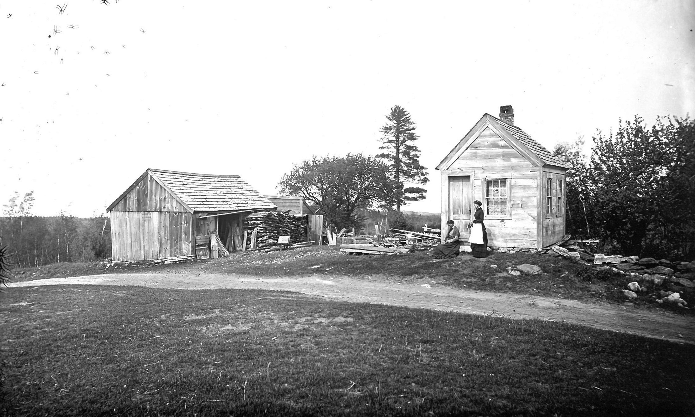
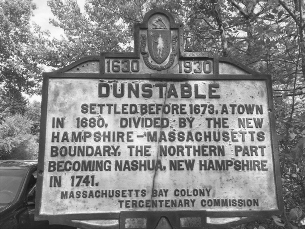
     “The province line as located in 1741 divided Dunstable into two towns (the New Hampshire portion later becoming Nashua) , and cut off large tracts from the northern potions of Dracut, Methuen and Haverhill. The next year (1741-2) Windham, comprising the southern part of Londonderry, was set off to form as separate parish or town.”

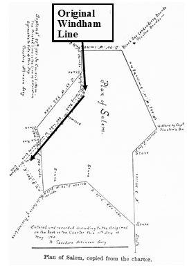
     The part of the present Windham-Salem boundary running from ’Clark’s Corner’ (the small offset on Derry line) south to the head of Hitty Titty Pond (Shadow Lake) is a portion of the original boundary of Londonderry.  If we extend this line through Salem Depot village to a point in the southern part of Salem where the Windham-Pelham line boundary would intersect it, we shall enclose the original area of Windham as it was during the first eight years of its existence as a separate municipality, its other boundaries being virtually the same as at present.” (A portion of Windham split off to join the town of Salem. In effect, the towns of Salem, Windham Pelham Hudson, and Nashua came into existence because of the border settlement.) 

    “In May, 1750, Salem was incorporated and the line between that town and Windham was made to run west of Hitty Titty and Policy Ponds, putting those bodies of water wholy in Salem, as well as a number of Scotch-Irish settlers who naturally belonged to Windham. This caused dissatisfaction and within two years, (January 1752,) the line was changed to run practically as it does at present, to the head of Hitty Titty Pond, and from there through that pond and Policy (Canobie Lake) from end to end, and on to the Pelham line. Morrson’s History of Windham does not mention the original Salem boundary running west of Policy Pond, but it is given in Gilbert’s History of Salem and shown by a plan. This change in the boundary lines gave back to Windham number of families living west of Policy Pond, and transferred some situated southwest of that pond to Salem. It was also decreed at the same time that persons living in the part of Salem which had been Windham might join with the latter town in ecclesiastical matters if they wished. A number of families did so affiliate, and paid the minister tax to Windham, everybody in those days having to pay a minister tax somewhere. This arrangement continued until 1798, when the place of worship here was transferred from the Range to the present center of town, no longer accommodating the Salem people.” Facts about Dracut and Haverhill boundaries, both of which lapped over the present territory of Windham, will be given later.”   

Windham Life and Times – November 13, 2020

The Border Dispute

Butterfield Rock | Indian Meadows II

William Harris in his Exeter Newsletter column says, “Butterfield’s Rock, one of the natural curiosities and noted landmarks of the town, (located on the grounds of Windham Country Club) has been known by that name  for nearly two hundred years. In the Londonderry Proprietors Records under the date October 29, 1723, occurs this record: ‘Laid out by the order of the town a farm given in Charter to Mr. David Cargill Junior containing one hundred acres of land lying and being to the southwest of the rock called Butterfield’s rock.’ It apparently took its name from a Jonathan Butterfield, of Chelmsford, to whom was laid out one hundred acres of land, June 8, 1721. This land, however, was not near the rock, as it was west of Beaver brook. August 30, 1728, he again received ninety-eight acres, but its location is not clear. Morrison’s History of Windham says that Butterfield owned land in Londonderry, perhaps including the rock, before the coming of the Londonderry settlers in 1719. When Dracut, first settled in 1664, was incorporated in 1701, its bounds included the south part of what is now Windham, and the settlers of Dracut and Chelmsford used to pasture their cattle in the wild lands and meadows here. They burned down the woods in the south part of town to improve the pasturage…”

     In fact, the land running between Cobbett’s Pond and Canobie Lake was once a huge Native American summer settlement where the Indians would grow the three sisters of corn, winter squash and pole beans. They had burned off this land creating what were known as “Indian Meadows.” A huge number of Indian artifacts were in fact found by the state of New Hampshire when they were reconstructing Cobbett’s Pond Road and arrow-heads were once commonly found on the shore of Canobie and Cobbett’s. A few years ago, my son found a round, fish net weight while diving in Lake Winnipesauke. As the Native Americans moved further north to avoid the advancing settlers, these meadows were coveted by the Europeans. You can imagine having to cut old growth timber with little more than an ax on your farm. The Indian Meadows were already burnt off or had small, new growth which could also be easily burnt off again. I often picture the Indian settlement as it must have looked in Windham. Running along the Range with crops growing and Indians fishing and hunting on Cobbett’s Pond and Canobie Lake. The crow is a Spirit Animal Totem, and I notice there is a murder of crows that congregate near the Range. Maybe they have been doing this since the time of the Indians, with corn nearby, for hundreds of years.

     “The north east corner of Dracut as first laid out, was apparently near Spear hill, east of the southern end of Cobbett’s pond. From there the line ran northwest four miles to the Dunstable line near Beaver brook somewhere in the region of West Windham, from there running south by the Dunstable line about four miles to Jeremy Hill in Pelham. The bounds of Londonderry, when incorporated in 1722 overlapped the Dracut line, and it was not until 1741 that the line between Massachusetts and New Hampshire was definitely settled, substantially as at present. Windham was set off from Londonderry in 1742. There is an old path, still usable, running through the woods from near Butterfield’s rock southwest to near E.A. Haskell’s, which has always been called the ‘Dracut Road.’ It would be interesting to know more than we do of the early days to which these old names carry us back.” W.S.H. If you open your eyes, past and present are both filled with beautiful mystery. 

Windham Life and Times November 6, 2020


L to R: The Park-Armstrong Farm. (Common Man) Map of disputed border. This rock was the  SW bound of the Cobbett grant.

Frank Johnson wrote an interesting article about a Massachusetts and New Hampshire granite boundary marker that once stood north of Canobie Lake. Most people are unaware that this southern portion of New Hampshire was disputed territory until settled by the British Crown in 1740. In fact, Windham’s founding in 1742, came about in large part because land grants could be settled and people could feel confident in their titles.

The Border Dispute Between Massachusetts and New Hampshire

     One of the big losers in the settling of the border dispute was the Massachusetts, Rev. Cobbett descendants who now found their large grant of Windham land invalidated by the royal ruling. You see, the Cobbett’s land in Windham, which ran to the shore of Cobbett’s Pond, became invalid, because it had been granted in Massachusetts. Since Massachusetts had no authority in New Hampshire, the grant was worthless. They later petitioned for redress and were granted a large tract elsewhere in the state.

     Alexander Park, emigrated from Northern Ireland in 1728 with the intent of settling in Londonderry NH. He arrived in Boston with his family but was forced to stay in Methuen for four years, Morrison says, “deterred from joining the Londonderry settlement on account of the uncertainty of obtaining valid title to lands. The uncertainty was caused by the dispute between New Hampshire and Massachusetts about State lines. In 1734, New Hampshire was erected into a separate government. Boundary lines were run and established, but all disputes were not settled until 1741. Another fruitful obstacle to his settlement was the great dissatisfaction which existed among the Londonderry settlers themselves, in regard to the division of land. When these latter differences were adjusted, and the ‘Cobbett’s Pond’  land laid out in farms, Alexander Park and his family permanently located in what is now Windham.  But the trouble with the State lines remained; so when on Oct. 8, 1734, he bought of Samuel Allison (one of the first sixteen settlers of Londonderry) the place now owned by Robert Armstrong, he required of said Allison a bond for money, so that if he should be deprived of said land on account said land lying in Massachusetts, he should be protected against loss. Then he erected his buildings…” It is very possible that the Massachusetts-New Hampshire granite marker was located on what had been Park’s land. This farm was acquired by Robert Armstrong through a marriage to Alice Park in 1803.  

    According to Wikipedia, “The Province of New Hampshire and Province of Massachusetts Bay had disagreements over their mutual boundaries. With respect to the southern boundary of New Hampshire, the two provinces disagreed on the meaning of “three miles northward of the Merrimack River, or any part thereof”. New Hampshire drew a line from three miles north of the mouth of the river, while Massachusetts claimed a line three miles north of the northernmost part of the river, taking its territory far north past what is now Concord, New Hampshire. New Hampshire appealed to King George II, who in 1740 decreed the boundary to run along a curved line three miles from the river between the ocean and a point three miles north of Pawtucket Falls (Lowell), where the river begins to turn north. From there a line was to be drawn due west to meet the western boundary of Massachusetts (fixed in 1773 with the Province of New York). The line actually runs slightly northwest to southeast, so it follows no line of latitude. This gave New Hampshire even more than it had claimed, as Pawtucket Falls was south of the mouth of the Merrimack. At this time, the present northern boundary of Massachusetts was established.”    

     You remember the Cobbett’s land grant that was annulled by the settlement of the border dispute. It had laid unsettled for many years because of uncertain title. In 1741, New Hampshire legislature chartered the Town of Windham and appointed Robert Dinsmoor, Joseph Waugh and Robert Thomson, to call the first town meeting in 1742. Not long afterward, the very large, empty tract of land, that had been granted to the Rev. Cobbett family, was granted by the New Hampshire town of Windham to the Dinsmore family.  My father and mother still reside on that original grant of land. The water frontage ran from the brook at what is now Castleton, to a large boulder that once sat in the water of Cobbett’s Pond near Gardner Road. The Parks-Armstrong grant was located south of the brook, along Cobbett’s Pond to Canobie Lake. The Dinsmore land went north up over Jenny’s and portions of Dinsmore Hill where the Governor Dinsmoor marker is today. “Gardner” is in fact a Dinsmore family name and my grandfather built a cottage there which he was forced to move on the ice to another location when his father sold a part of his land to Edward Searles about 1912.   

Windham Life and Times – October 30, 2020

The Approaching Neo-Feudal Word.

Newell Farm Windham NH. Baldwin Coolidge Photograph. SPNEA

Prior to America’s Golden Age, in the mid-twentieth century, when national wealth exploded and a wide swath of the population was lifted into middle class, half the people lived in poverty. According to the Foundation for Economic Freedom, 56% of families in the United States were poor in 1900 compared to 13% in 1967.  Today, the trend is moving in the opposite direction.  There is a fascinating new book, “The Coming of Neo-feudalism” by Joel Kotkin in which he explores this ongoing phenomena occurring all over the world.  “Following a remarkable epoch of greater dispersion of wealth and opportunity, we are inexorably returning towards a more feudal era marked by greater concentration of wealth and property, reduced upward mobility, demographic stagnation, and increased dogmatism. If the last seventy years saw a massive expansion of the middle class, not only in America but in much of the developed world, today that class is declining and a new, more hierarchical society is emerging…The new class structure resembles that of Medieval times. At the apex of the new order are two classes―a reborn clerical elite, the clerisy, which dominates the upper part of the professional ranks, universities, media and culture, and a new aristocracy led by tech oligarchs with unprecedented wealth and growing control of information.” Solving this difficult dilemma and reversing this trend is the challenge of 2020. America must come to grips with this unfolding problem or the middle class will slowly disappear and the social safety net will break, leaving the poor and newly poor to eke out an existence in some bleak place like Miss Newell’s farm.