George Washington’s First Battle in the Revolutionary War
I have included this historical summary of the Siege of Boston by Mary Stockwell, Ph.D from the George Washington Presidential Library. This will give the background to the letters home from Windham residents who were part of the engagement. I will publish those letters next week including ones from Robert Dinsmoor and John Morrion.
“The Siege of Boston was George Washington’s first campaign as Commander-in-Chief of the Continental Army. Disdain for British troops stationed in North America to enforce royal policies grew among colonists, especially in cities such as Boston. Subsequently, the British occupied Boston at the outbreak of the American Revolution, and eventually 11,000 British troops were stationed there. American forces undertook the Siege of Boston to force out the British from April 1775 to March of 1776, when the British evacuated the city.”
“Militias contained the British to Boston in April 19, 1775 following the battles at Lexington and Concord. Freeing Boston of British control was an early priority in the war, as it was a critical port and ideological American stronghold. However, Americans faced early defeat attempting to advance towards the city in the Battle of Bunker Hill on June 17, 1775. Understanding the need for more competent military leadership, the Continental Congress elected Washington as Commander-in-Chief of the Continental Army, and he was bound for Boston to continue to the siege.”
“Quickly, Washington was charged with forming military companies into an army and directing the siege of Boston. Knowing that he would be away for many months, Washington wrote to his wife, Martha Washington, “I shall feel no pain from the toil or the danger of the campaign,” he confessed. With the future of the Revolution uncertain, Washington worried that Virginia’s Governor Lord Dunmore would attack Mount Vernon and even imprison his wife while he was fortified outside of Boston.
“Upon arriving in Cambridge in early July, Washington proposed an attack on Boston. However, his officers were against it as the British were still receiving supplies by sea. They urged Washington to wait until the waters around Boston were frozen.”
“Washington shifted his priorities, and instead sent an army to Quebec who ultimately failed in their invasion. He also ordered Henry Knox to march to Fort Ticonderoga and bring back the post’s artillery. Knox returned to Cambridge in January 1776 with fifty-nine cannons to assist in future efforts to capture the city. Throughout the winter, Washington contained the British under the leadership of General Thomas Gage to the confounds of Boston.
Washington desired to “bring the Enemy out of Boston” with a nearby attack in Dorchester Heights that would restrict British usage of the greater harbor. On the evening of March 4, 1776, Washington directed his men to take the cannon retrieved from Fort Ticonderoga up Dorchester Heights south of the city. In a more assertive turn, Washington also ordered his troops in Cambridge to fire on the British. Despite a strong British defensive, the Americans held their position in Dorchester Heights.”
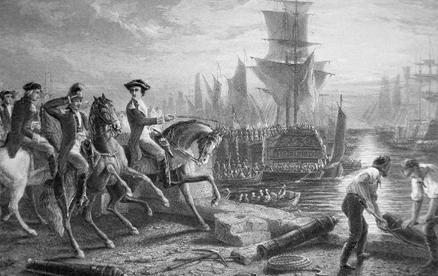
“General William Howe sent troops up Dorchester Heights to undermine the American fortification, but a snowstorm prevented the assault. Fearing a brutal bombardment at their advance, he decided to leave Boston. On March 17, 1776, known afterward as “Evacuation Day,” 11,000 British soldiers and hundreds of Loyalists left the city by boat, leaving significant amounts of artillery. his victory was crucial in preventing the British control of a major port in which to receive supplies and troops. Additionally, the victory boosted morale for American independence.” Washington marched into Boston on March 18, but there was little time for rejoicing. He rightly suspected that the British turn their attention to New York City. In the summer of 1776, Washington prepared to launch the New York Campaign as the British moved to occupy another critical port city.” Mary Stockwell, Ph.D., revised by Zoie Horecny, Ph.D., 15 April 2025
https://www.mountvernon.org/library/digitalhistory/digital-encyclopedia/article/siege-of-boston