

The Border Dispute
The Royal Border Settlement 1740-1 (IV)
William Harris says that, “When Dunstable was chartered by Massachusetts in 1673, and the boundaries surveyed the next year, the northeast corner was a ‘pine tree marked F standing within sight of Beaver Brook.’ From the corner the line ran a little west of south to near Jeremy’s Hill in Pelham and on to the Merrimack River. This probably cut across what is now Windham.”
“When Dracut was incorporated in February, 1701-2, its eastern boundary was described as running from a point on the Merrimack River ‘due north six miles,’ then by a northwest line, described as four miles long, it ‘closet to the Dunstable line” at the pine tree bound already mentioned, thence following the Dunstable line southward about four miles.”
“This pine tree bound forming the Dunstable-Dracut corner is located by Kimball Webster in his history of Hudson (pp. 145,154) as being on the northward side of Beaver Brook about 112 rods down the brook from the present eastern point of Hudson, and a short distance above the spot where the Worcester, Nashua and Rochester Railroad crosses the brook.”
“In December, 1722, the Dracut selectman perambulated their north line across what had been eleven years before incorporated as Londonderry and which was destined about eight years later to become Windham. They evidently did not intend to give up their claim to a strip of land a mile and a half wide and four miles long, liberal measure, which their original bounds included, and which they would have retained if the king had decided to run the province line straight west from its beginning at the ocean.”
“Morrison’s History of Windham does not mention the fact that the southern part of town formed uncontestably for a score of years (1702 to 1722) a portion of the territory of Dracut, and was claimed by them still longer. The Dracut line crossed some natural features which it is possible to identify, so that it can be quite accurately traced.”
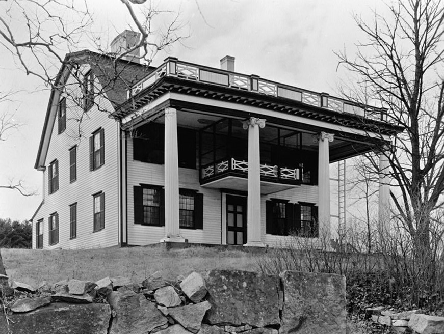
The Tyng Mansion, built before 1675 by Colonel Jonathan Tyng, sat along the western banks of the Merrimack River.
The northeast corner of old Dracut does not appear to have been marked by any special feature, but it is stated by local historians that the present boundary between Dracut and Methuen is a part of the original line, so that by extending it and drawing this old north line of Dracut it is easy to see about where the corner must have been— near Spear Hill and not far west of the south end of Canobie Lake. In a petition of 1742, given in Edgar Gilbert’s History of Salem (p.98) this language is used: ‘So running by said pond (Policy) to the southwest part then by Dracut line,’ etc., indicating that Dracut line came near the end of the pond.”
“The Dracut-Methuen line on any modern map runs a good many degrees west of ‘due north,’ and moreover it is much more than six miles to the supposed corner and it is more than four from there to the Dunstable-Dracut corner. The first fact is explained by supposing that the surveyors of those days ran by the compass needle without making any corrections for declination. There is a record of a survey in 1674, quoted in B. Chase’s History of Chester (p. 11) which says, ‘We ran due northwest according to the compass, not allowing any variations,’ etc. The magnetic declination at present is about 13 degrees west. What it was two hundred years ago I do not know, but all the old lines described as due north and south or east and west vary greatly from these positions when laid down on a modern map.”

Gunter’s Chain & Surveyor’s Compass. Courtesy of the New Hampshire Historical Society “Gunter’s chain was developed in 1620 and consisted of 100 links, each measuring 7.92 inches, for a total of 66 feet of measurement. The chain included brass rings at every 10 links to facilitate partial measurements. In practice, the chain is stretched out along a defined path and secured to the ground with steel pins. The measurement is then recorded and the process is repeated until the surveyor reaches the final endpoint.”
“The overrunning of the measure was also a characteristic of the early surveys. Land being abundant and the surface uneven, they did not intend their measure to fall short. There is an intimation in the History of Chester (p.30) that it was customary to allow 11 chains for 10, and Rev. J.G. McMurphy in Early Londonderry Records (Vol. 2, p. XVII) says it was the practice when advancing the chain to place the pin forward as far as one could reach, thus gaining about six feet on every chain-length.”
The record of the perambulation of the Dracut north line in December 1733, is found in the Dracut town records, (vol. 1, p. 285,) its significant features are that proceeding towards the northwest, the line crosses in succession ‘Goldings pond otherwise called Cobets pond,’ south of its outlet; ‘Goldings brook’ the outlet; ‘Drye pond,’ and ‘Tyngs meadow.’ The identification of the last two localities has been the result of considerable study.”
