
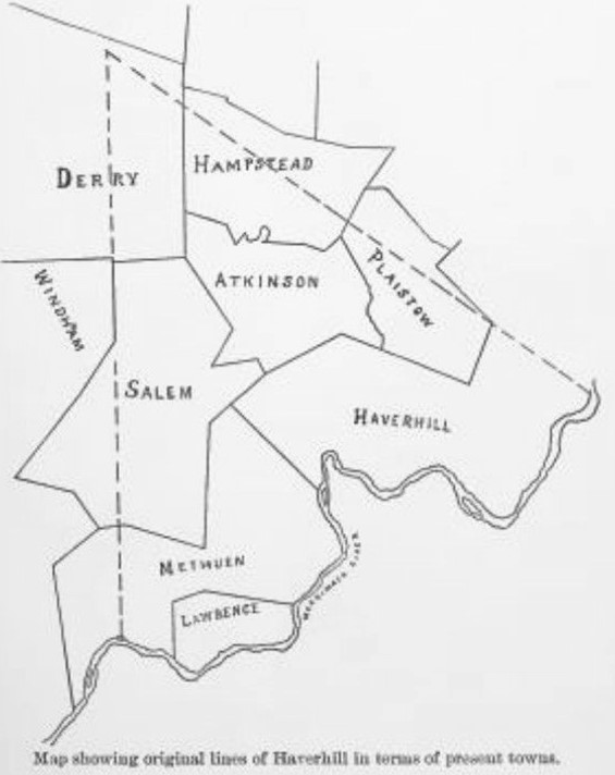
The Border Dispute VI – The Haverhill Claims
“The location of the Haverhill west boundary is quite perplexing as that of the Dracut north line. G.W. Chase in hist History of Haverhill (1861) devotes much space to the subject, but yet he does not locate the line with any definiteness. Edgar Gilbert in his History of Salem, (1907) on pages 37 and 51 makes it coincident with the old Londonderry line, of which the present boundary of Windham from the Derry line to Hitty Titty Pond is a part, although on page 117 of the same book he shows the Haverhill line as farther west than Londonderry, as it undoubtedly was.”
“We are to remember, first, that this line was intended for and considered a north and south line, and second, that, as laid down on any modern map, it would run a number of degrees west of north. The General Court of 1640 granted the right for a plantation at Pentucket (Haverhill), but did not assign any bounds. Two years later the settlers procured from the Indians a deed to a tract extending eight miles west from Little River, six miles east from the same point, and six north….There is no definite record of the boundaries of the town being laid out until 1666, although as early as 1650 the General Court appointed a committee for the purpose and in 1660 the Court summoned the town ‘to shew a reason why they have marked bound trees at so great a distance from their towne vp Meremacke River, & also to give an account of the bounds of theire towne & upon what right they lay clajme to so long a tract of land.’ ” You have to give those settlers credit as you see the attitude of “go big or go home,” on full display again!

“In 1662, when the grant to Rev. Thomas Cobbet, of Ipswich, Mass., was surveyed, it was described (Massachusetts Colony Records, vol. 4, part 2, p.78) as being located to the westward ‘from a swampe that joynes upon the Hauerill bounds.’ This swamp is believed to be the low ground near the present Searles schoolhouse in this town. In 1669, when Rev. John Higginson, of Salem, Mass., had a grant laid out adjoining Mr. Cobbet’s (ibid., p. 441), a certain tree on the latter’s line was stated to be ‘the aunttient bound marke of Haurills perpendicular ljne.’ In the same description ‘a great pond, formerly called Hauerill Bound Pond’ (later known as Policy Pond and now Canobie Lake) is also mentioned in such a way as to leave no doubt that at some time previous to Mr. Cobbet’s grant the west line of Haverhill had been in some way fixed as to touch this pond and in all probability to cross a portion of it….However, the description of Mr. Higginson’s tract makes it clear that it lay between the pond and the Haverhill line as recognized at that date, 1669, so that we conclude that the line as fixed by the surveyors of 1666 ran wholly east of the pond, but probably not far from it.”
“The interesting record (Higginson’s grant) is in part as follows” ‘The ffarme conteineth seven hundred acres or thereabouts, bounded vpon the east with Hauerill lyne, **** & bounded vpon the south by the land of Mr. Atkinson, to a great pond, formerly called Hauerill Bound pond, & is bounded with a heape of stones & trench at the southeast corner of the pond next to Mr. Atkinson; & is bounded by said pond vpon the west vntill it cometh cleare of the ponds east end, & then rangeth westward by the side of the sajd pond, to the land of Jerimiah Belchar on the west, vntill it comes to the land of Mr. Cobbet, there being **** a white oake tree, marked next to Mr. Cobbet, which white oake was the auntient (ancient) bound marke of Haurills perpendicular line, & thence raingeth east cleere of Mr. Cobbet, & bounded by upon Mr. Cobbets vpon the west, to a stooping white oak tree marked with T C & I H; from thence running northerly to a black oake tree, marked on the north side of a brook, commonly called the western most branch of the Spicket River; **** & from thence it rangeth easterly *** vntil it comes to the Hauerill ljne.’ “ W.S.H.
