Windham Life & Times – March 3, 2023

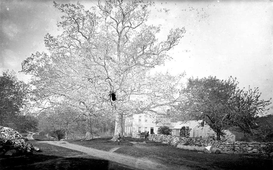
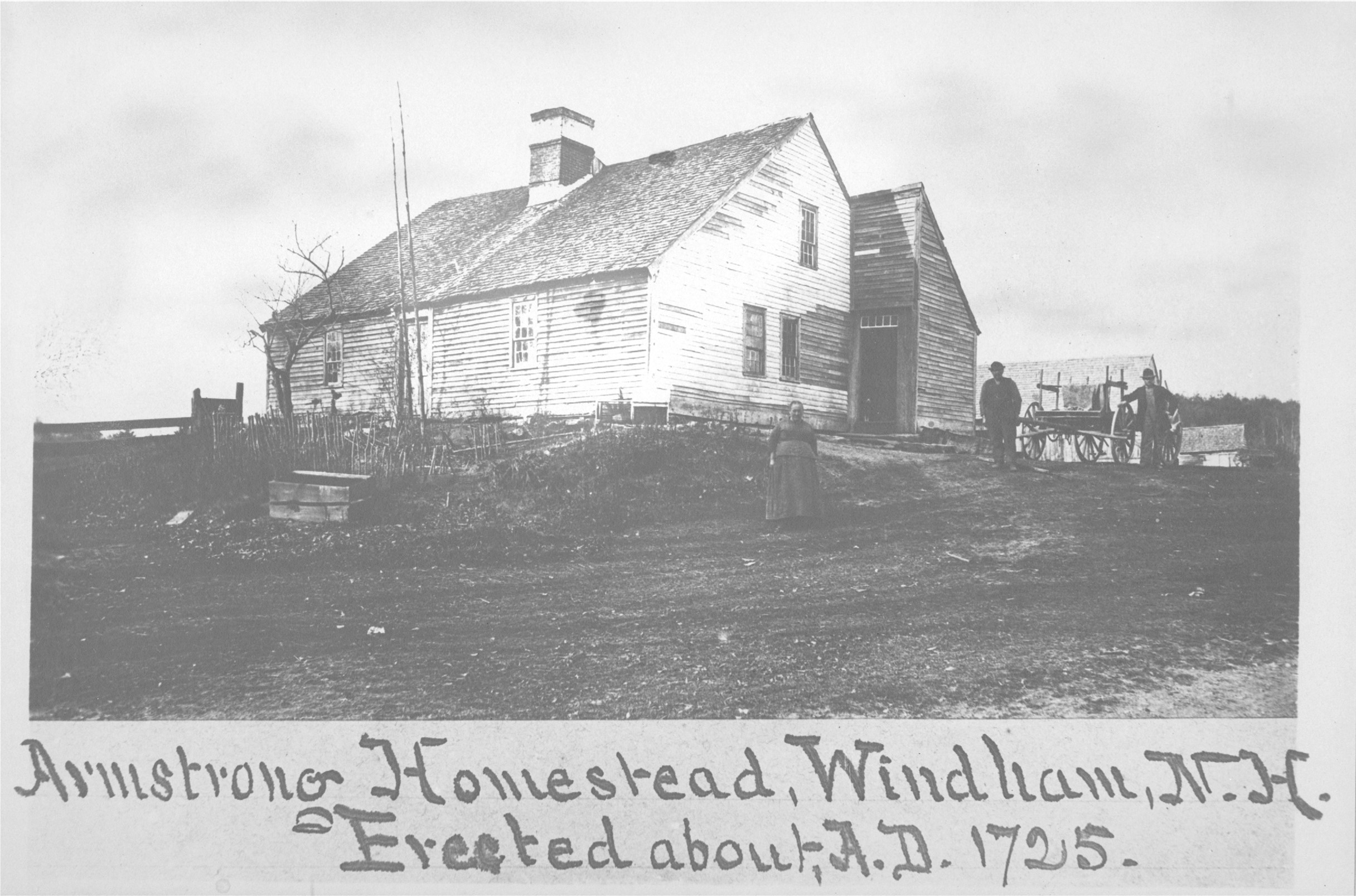
The original Armstrong Homestead is still standing today on Londonderry Road.

The 300th+ Anniversary of Settling in Windham

The Armstrong Family has been in Windham since 1722

    The Armstrongs have always liked to boast that they got to “Windham” before the Dinsmores, which just might be true. However, the old records are also just a little murky.

     The Armstrong family sailed to America from Northern, Ireland as part of the great 1718 Ulster migration. They followed the Rev. James McGregor and with other families went to Maine. Three Armstrong brothers, with wives, were on the ships. “We know certainly that several brothers named Armstrong landed on Richmond Isle near Falmouth, the old name for Portland and Cape Elizabeth, and founded families. James Armstrong and Mary his wife brought with them an infant son Thomas. John Armstrong and his wife brought an infant son James. Both children were born in Ireland in 1717.”

    Robert Armstrong was also one of the party who landed in Falmouth, but he went to Portsmouth, New Hampshire and then to Londonderry…“The core of the company that settled Londonderry, New Hampshire, in April 1719, consisted of eighteen men with their families,—namely Robert Armstrong, Rev. James McGregor, James McKeen, etc. etc.” According to L.A. Morrison, “Robert Armstrong was one of the original proprietors of Londonderry, (*which comprised Windham, Derry, Londonderry and parts of Manchester), on June 21, 1722. There was a ‘home lot and 2nd division’ laid out to him, Dec. 21, 1722, and in the charter of the town it was provided, ‘That the Proprietors of each share shall build a dwelling-house within three years and settle a family therein.’ The fact that he owned this land after the three years would imply the conditions had been met.”

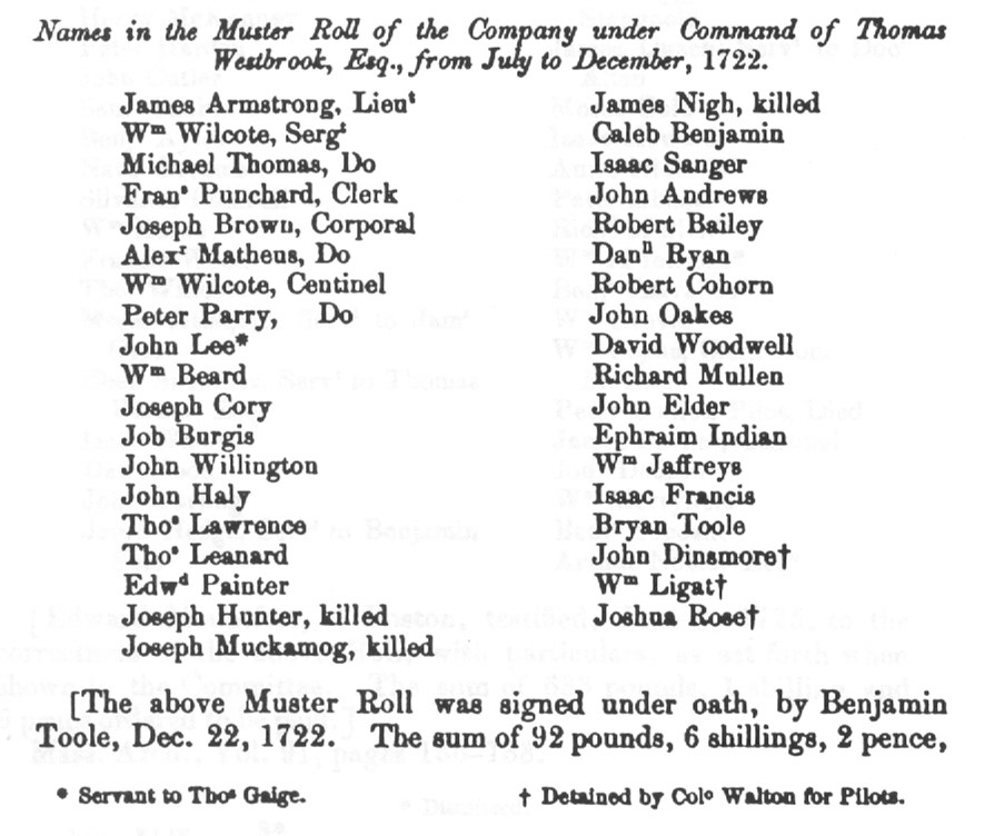
” Interestingly, James Armstrong (Windham Robert’s brother) had been made a Lieutenant by July of 1722, in the Company under the command of Col. Thomas Westbrook. John Dinsmoor, was also in this company from July to December 1722, having been conscripted as a guide after he had been captured by Indians earlier that year. So old Ulster friends, John Dinsmoor and James Armstrong served together in this military company in Maine.

    “Whom Robert Armstrong married, or when he died is not known. He is undoubtedly the ancestor of the Armstrongs in Windham. Tradition says that the emigrant ancestor, of Scotch blood, emigrated from Northern Ireland, bringing two children with him. One died on the passage, which he buried in ‘the deep, deep sea.’ He often alluded to this painful experience as the greatest grief of his life. This could not have been John Armstrong, as he was born in 1713; came to America when a boy, and his oldest child was born in Windham; Sept 8, 1738. It must have been Charter Robert Armstrong, the proprietor, who was here with the first settlers in 1722, who lost his child on the passage, leaving an only son, who was John, of Windham, 9 years of age in 1722, If stronger evidence is needed, it is found in the fact that Charter Robert Armstrong’s Christian name has cropped out in successive generations, and is now honorably born by a living representative in Windham”

      Robert’s son was Deacon John Armstrong  who was a weaver. He was born in 1713 near Londonderry, Ireland and emigrated when young. He lived on the Armstrong “homestead” which is still standing on Londonderry Road, settling there previous to 1738. The current house was built about 1762. He was a Selectman and a moderator. He was a “trustworthy and respected” citizen and active in the Presbyterian church. He had eight children including David, who was born June 11, 1747. He succeeded his father on the family homestead. He signed the Association Test in 1776, was a surveyor and constable. He married Elizabeth Hemphill, January 8, 1775. They had twelve children. She died January 2, 1839 and he died June 21, 1836.”

The Armstrong Homestead in the Range was originally owned by Alexander Park, whose daughter Alice married Robert Armstrong in 1803.    

“Robert was born on April 6, 1779. He married July 28, 1803, Alice, daughter of Alexander and Sarah (Maxwell) Park. As there were no sons in the family he became a son to Mr. Park, and resided on the farm with his wife’s parents in Windham Range. She died there November 10, 1830; he died there August 21, 1849. (This is the Armstrong farm that is now the Common Man.) This was one of the old “Range” farms that were laid out between Cobbett’s Pond and Canobie Lake which had water frontage on both.

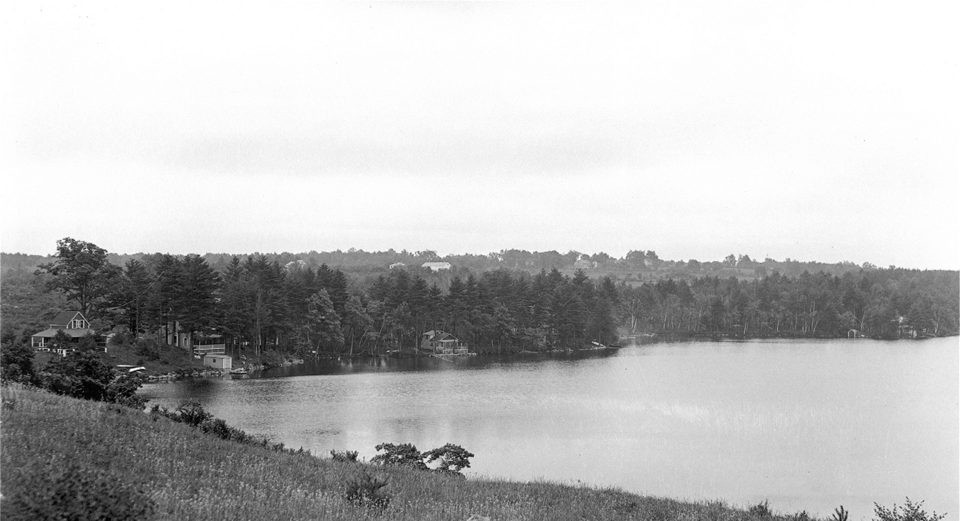
    A photograph of the Armstrong farm frontage on Cobbett’s Pond taken form the neighboring property.

His son Robert was born in February 21, 1812 and succeeded his father on the original homestead of the Park family. He married Mary B, Emerson. “A farm not naturally abundant has been made to yield abundant harvests…” They had four children including George F. Armstrong who succeeded his father on the farm.

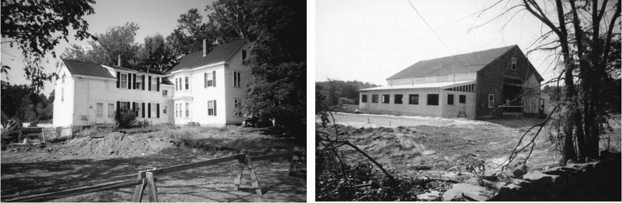
The Victorian era home built by George F. Armstrong. These photographs were taken when Alex Ray was converting the barn into the Common Man Restaurant. The thing I remember most about that barn is the night the race-horse Drill-Rod was born, and my mom and I stopped by to see him… right there about where the first floor window is located.

     According to Rural Oasis, George F. Armstrong built the newer (white) Victorian home on the property and his sisters then occupied the original homestead followed later by Maurice Armstrong from 1926 through 1945. George and Dorothy Armstrong occupied the homestead until 1957 when it was sold to the Foden family. The Armstrongs developed camp lots on their farm on the shore of Cobbett’s Pond and on Canobie Lake along what is now West Shore Road.

Maurice’s sons, George and Robert lived in Windham and operated businesses here. Bob ran an excavating business and developed a section of Woodvue Road on Canobie Lake. George and his sons operated a well drilling company for many years and also had race-horses. They were harness racing horses and George’s son Alan was often the driver of the sulky. I sill remember riding in the back of the bronze Chevy wagon, Dot at the wheel, nobody wearing seat belts. I also remember the night we were visiting at George’s home on Range Road, when a car driven by one of his sons went flaming by, at what seemed at the time, to be over 100 miles and hour (and possibly on its side, but my memory is foggy).

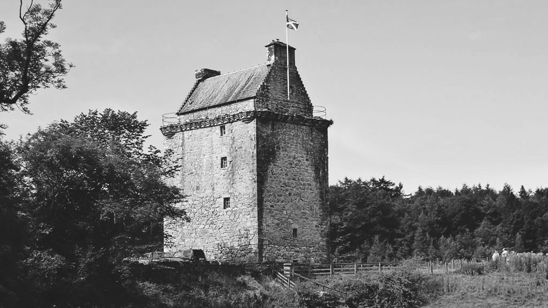
Gilnockie Tower home to the Armstrong clan on the Scottish Borders.

    The Armstrong family are descended from the fierce, Scottish border clan, whose fortress was Gilnockie Tower that is located between Canonbie and Langholm on the River Esk. Originally known as Hollows Tower, it was built in 1520 by Johnnie Armstrong, who was the famous Scottish outlaw or “reiver,’ who raided across the border in England.

Chronicles of the Armstrongs

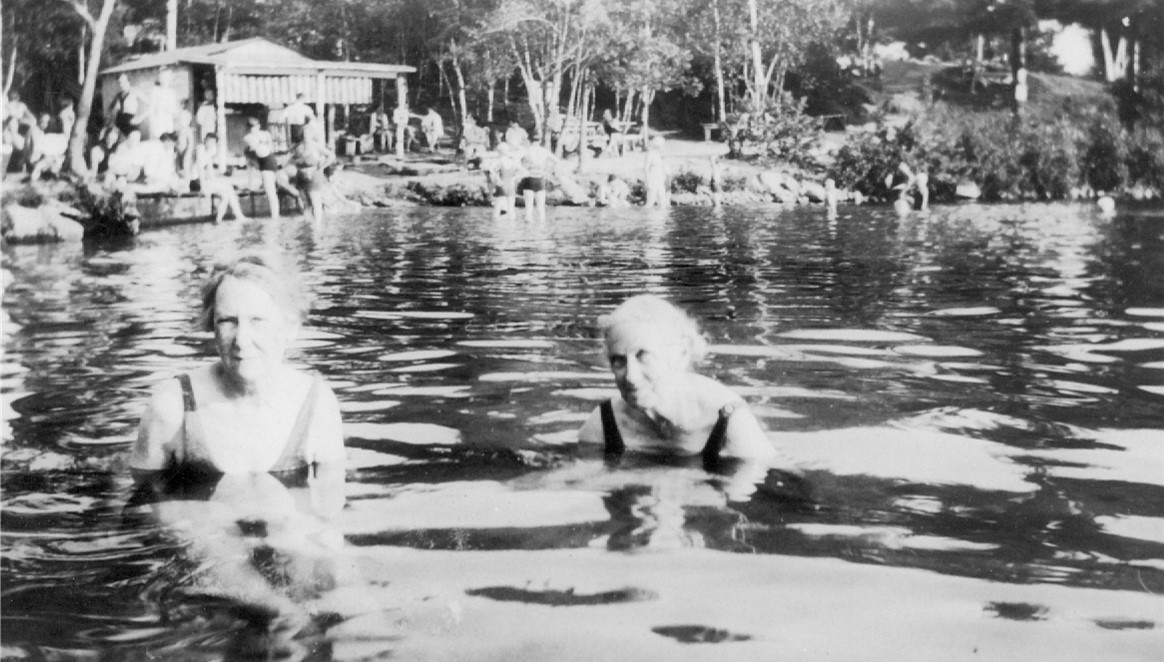
Armstrong Beach and the rustic concession stand.

Armstrong Beach was operated by the family many years. My grandparents leased the concession stand one summer. It was one of five, public bathing beaches on the pond. According to Rural Oasis, “At one time this brook was the boundary between Dunkan and Armstrong Beaches and their was a dispute between the properties. “When Bill Ayer, owner of John Dinsmore’s farm on Indian Rock Road, sold his lake property in he 1930’s to George Dunkley of Salem for a public beach the question of correct boundaries arose. Dunkley’s deed read to the brook. Maurice Armstrong owner of the already established Armstrong Beach, claimed the line was several feet to the west of the brook. A bitter dispute, followed by legal actions with many witnesses, proved the brook was the legal boundary. Like the Hatfields and McCoys, George Dunkley and Maurice Armstrong harbored bitter feelings for the rest of their lives.” Apparently, long after, dead fish would go flying across the brook onto the opposite properties in a subtle war of attrition.

George Dunkley sold Dunkan Beach to Jeannette and Bob Comtois in 1966. They improved the property and in the spring of 1971 they decided to sell the property. George Dinsmore and George Armstrong who were good friends, decided to buy Dunkan Beach and combine it with Armstrong Beach and formed Castle View, Inc. In 1974, due to other business pressure George Dinsmore sold his share.

I worked at Dunkan Beach during the several summers that my father was involved in the operation. It was a very interesting place on a weekend afternoon. Parking was always packed on sunny days, 5 dollars on Sunday, and it was all cash. We used to sell hundreds of vinyl blow up rafts each day which would often return with tears when they popped. “Sorry no refunds.”

One day the place was packed and there was a near riot over an accusation of a rape having occurred on the raft. After things cooled down the two families involved were drinking beer together in the afternoon sun. Another day, somebody called in that a bomb had been planted in the pavilion. We called the Windham chief of police to the scene. Old Willis Low arrived, pipe billowing smoke, and he said to my father; “George, if we announce over the loud speaker that there is a bomb, there will be a stampede out of here, and people are sure to be hurt or even die. So my advice to you is that we forget about the whole thing and see what happens.” Nothing happened!

One day there was a couple hitting it pretty hot and heavy, laying on a blanket on the beach. So the decision was made to send out George Armstrong to get things under control. He stood there, stammering, “Miss! Sir! We don’t allow this on the beach!” “It is a family beach.” They totally ignored him and kept at it. George slunk away and we all had a good laugh.

The clientele changed and the era of public bathing beaches came to an end. The Armstrong family decided to build a function hall on the property which they have successfully operated for a number of years. The Armstrongs still own and operate Castleton on Cobbett’s Pond. I was thinking of having an open bar at my wake, I wonder if Castleton would host it? They could prop me up in a corner and my friends and relatives could toast my trip into the netherworld. I’m only slightly kidding!

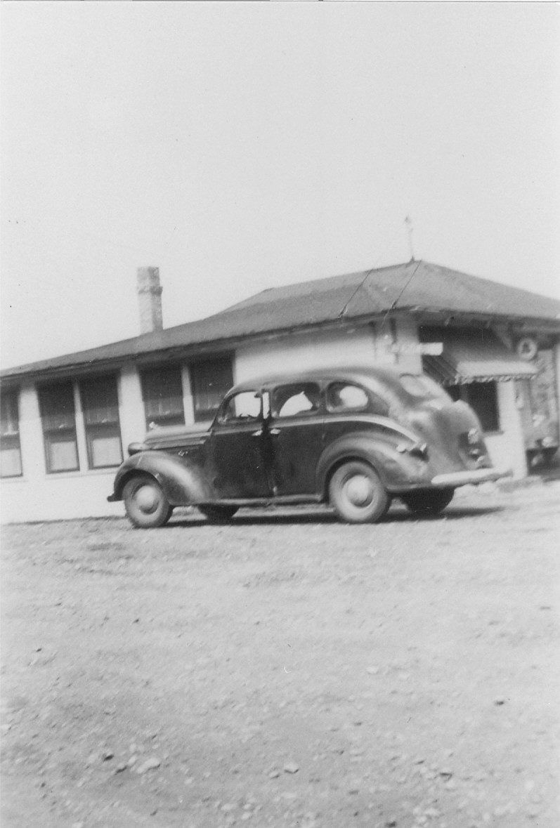
Maurice Armstrong’s car at the “Robin’s Nest” on Route 28 in Windham.

“The Great Race.”

The Robin’s Nest was the local drinking establishment favored by Windham folks. People would meet there to have a beer and swap stories. So you know how when you’re drinking with your buddies, things can sometimes get out of hand? For example, I have heard recently how two local real estate developers, at a local bar, almost came to fist-a-cuffs over who was worth the most.

Anyway, George Dinsmore Sr. and Maurice Armstrong were having drinks at the Robin’s Nest. Somehow, the subject of which one of them could run faster came up in conversation. Everyone in the bar joined in the debate, egging the contestants on. Soon the dispute became heated, no doubt lit by the drinks. It was decided that the only way to settle the matter was for the whole crowd at the bar to go outside and conduct a race on the busy, state highway, Route 28. Wagers were made, the two forlorn and “slightly” inebriated runners were lined up and a race course designated. Bam! Off they went. Imagine what the motorists on Route 28 must have thought! I really don’t know who won, if anybody, but I know the Armstrongs are bound to claim it was Maurice…who won.

When I was a kid, I used to sit enraptured listening to my dad and George Armstrong talking at my house. They would be smoking and drinking beer, hatching plots, talking business deals, gossiping and laughing…I remember the laughter the most! Keeping the pipe lit was always a challenge…but good friends…I’ll never forget them together.

Happy 301st, to the Armstrongs!

Windham Life and Times – September 6, 2019

John “Daddy” Dinsmoor: Maine Pioneer

John Dinsmoor grave marker on the Cemetery on the Hill, Windham NH

On the Cemetery on the Hill, in Windham, you can find the grave of John “Daddy” Dinsmoor who was the first of the family to come to America. There is an impressive granite monument there to mark the spot, placed there by a descendant, James Dinsmoor in 1902. While a generous gift, not everything etched in stone is necessarily true. The inscription unfortunately conveys misinformation about the timing of John Dinsmoor’s arrival in America which was much earlier than 1724.

Over the past several weeks, I have been mucking about in ancient Maine history, and I have stumbled upon the documentary, written proof, that John Dinsmoor was in Maine, and was indeed taken as a captive of the Indians, at St. Georges, Maine, in June of 1722. This proves that Daddy Dinsmore was definitely in Maine prior to 1722. The entire event is described in detail in a letter from Colonel Thomas Westbrook, an English commander, dated September 23, 1722. John Dinsmore’s name, clear as day, was in the Index of the New England Historical and Genealogical Register Vol. 44.  As it turns out, John Dinsmoor was made a captive by the Penobscot Indians, and taken to what is now “Indian Island” in the middle of the Penobscot River exactly as was related in the very detailed and eloquent, family oral tradition given by Robert Dinsmoor.

I also have to fall back on Rev. A.L. Perry, the Professor of History and Political Economy at Williams College, who states emphatically in The Scotch-Irish in New England that the Dinsmores were part of the 1718 migration from Northern Ireland: “Besides Mr. Boyd, who had stayed the summer in Boston, where he found already settled a few scattered and peeled of his own race and faith, there were three Presbyterian ministers on board, —Mr. McGregor, of blessed memory, Mr. Cornwell, and Mr. Holmes. Those best off of all the passengers were the McKeens, the Cargills, the Nesmiths, the Cochrans, the Dinsmores, the Mooars, and some other families— were natives of Scotland, whose heads had passed over into Ulster during the short reign of James II…” As one of the wealthiest immigrants, Dinsmore could have had the means to purchase a large estate or tract of land in Maine, especially considering the fact the many of the land speculators were giving land away for free or on a payment plan in order to induce settlement in this wild frontier, which was under constant threat of Indian attack, even after the 1717 “peace treaty” with the Eastern Indians.

        I also reread the grant of land to John Dinsmoor in Londonderry from the proprietor’s records of 1723-4. This dating would verify that John Dinsmoor stayed in Maine many months after his captivity in 1722. We now know that he was detained as a “Pilot” or scout for Colonel Westbrook after being released by the Indians. The land was “bestowed” as a gift to him and the grant was conditional that he or his son “settle this place in the space of a year after the peace is Concluded and if so be that he or his son does not settle said place against a perfixt time yet then and at yet time said land Shall fall to the town or said grantees…”  What peace? The only war raging in New England at that time was the Indian War in Maine, so it must be alluding to that and additionally to the fact of John Dinsmoor’s preference, which if possible, was to return to his holdings in Maine. What was so special about his home in Maine that he wanted to return to it when tranquil Londonderry beckoned?

Was it possible that his home was more than a hastily constructed cabin in the woods? Could it rather have been a stone house constructed with his own hands at some place in the vicinity of St Georges?  John Dinsmoor was a stone mason and he may have been employed in construction at the settlement of St. Georges. When he came to Londonderry he built himself a stone house and also built many stone houses in the area. The construction of stone houses in 18th century (the 1700’s) New England is very rare.  The vast majority of homes are of wood frame construction. Could it have been that he had also built himself a stone house in the St. Georges area that he wanted to return to and what would be the rare chance that it could still exist? Unfortunately, land titles were pretty much non-existent at that time in Maine, and many of the Scotch-Irish pioneers in Maine had to petition the government later in the century with sworn affidavits to prove they had occupied their land.

So let’s begin again with the account of John Dinsmoor in Maine, by Robert Dinsmoor in his introduction to his book of poetry: “My father’s grandfather, John Dinsmoor, was the oldest son of this Scotchman, who came to America about the time the first settlers of Londonderry came (1718). He is yet remembered by many of the old people, and very respectfully called Daddy Dinsmoor. But, whether from accident, I know not, he was landed at a place called Georges, where there was an English fort, in the district of Maine. There he built a house, and the Indians which traversed those woods, (I believe they were of the Penobscot tribe,) became very familiar with him, calling him and themselves all one brother. This was about the commencement of the war between Great Britain and France.”

One day, when Daddy Dinsmore was shingling his house, the Indians surrounded it with a war-hoop, ordered him down saying, ‘no longer one brother, you go to Canada.’ He was taken and kept with them three months. The Chief’s name was John, and Daddy Dinsmoor became his waiter, and ‘found grace in his sight.’ On a certain day, Captain John was called to attend a council of war, and in his absence, Old Daddy was accused by two squaws, of being on a certain point of land near the shore, in conference with some Englishmen, and although in the absence of the chief, he was condemned to be burnt. He was accordingly bound to the tree, and the fatal pile made around him, and that instant to be set on fire, when providentially, the captain returned, and commanded his execution be delayed until inquiry should be made with respect to the truth of the charge, alleging if it was true, their tracks could be seen, as the place was a very sandy point.” (My father tells me that his father told him that John was involved in a little hanky-panky with the Captain’s women, however, George Dinsmore Sr. was known for telling tall tales and then watching the reaction of his incredulous listeners, so I have to believe that this is merely a family legend.)

The charge was soon proved to be false, and he was reprieved. The last three days he was with them, they traveled almost night and day, a great part of the time at a ‘dog trot,’ carrying their canoes with them. When they had a river to cross, as soon as the captain was seated in the Bark, it was Daddy Dinsmoor’s office to push it off and jump in after; and having performed this duty at a certain river, the captain being resolved to set him at liberty, forbade him to step in. He plead for leave to get in, but the chief replied ‘No, you much honest man, John—you walk Boston.’ Daddy answered, ‘The Indians will kill me.’ The captain then told him how, and where he could find a cave in a rock, where he must lie three days, and in that time the Indians would all be past.  He gave him some bear’s grease and a few nuts, saying ‘Indians and French have this land, you walk Boston, John, then take English canoe, walk your own country—you much honest man John.”

My father’s grandfather, then took his solitary way, and found the rock as the captain had told him. When he lay there three days and nights, he saw the Indians pass tribe after tribe, until they were all passed. Then he arose from his cave, and thought he must dies of hunger; but by chance, or by providence, rather, he found some cranberries, which supported him until he arrived at Fort George. From thence, he got his passage to Boston, and from thence he visited his old friends and countrymen in Nutfield, now Londonderry. They had all been acquainted with Daddy Dinsmoor, in Ireland. For the respect they had for the man, and perhaps moved by the narrative of his sufferings, which no one doubted, the proprietors of Londonderry, made a gift of one hundred acres of excellent land and confirmed by deed, to him and his heirs forever…Daddy Dinsmoor lived ten years after my father was born. He and his son being both masons. They built a number of stone houses in town, which served as garrisons in the Indian war. (And I really believe, that his once being an Indian captive, was his inducement to build a stone house on his own land, in Londonderry) The remains of many of those houses are to be seen at this day; and a great many stone chimneys, as no brick could be had. His name was ever held in honor by all who knew him.”

Windham Life and Times – April 12, 2019

Nutfield 300

The First Settlement: By Land or River?

“…The company followed a trail from Haverhill about fifteen miles through the woods.” (But did they come by land? Not according the John Greenleaf Whittier who was intimately acquainted with the Scots-Irish in southern New Hampshire. In his book, Old Portraits and Modern Sketches Whittier describes the pioneer’s journey as follows: “In the early part of the eighteenth century, a considerable number of Presbyterians of Scotch descent, from the north of Ireland, emigrated to the new world. In the spring of 1719, the inhabitants of Haverhill, on the Merrimack, saw them passing up the river in several canoes, one of which unfortunately upset in the rapids above the village. The following fragment of a ballad celebrating this event, has been handed down to the present time, and may serve to show the feelings even then of the old English settlers toward the Irish emigrants:


‘They began to scream and bawl,

As out they tumbled one and all,

And, if the Devil had spread his net,

He could have made a glorious haul!’


     “The new comers proceeded up the river, and landing opposite the Uncanoonuc Hills, on the present site of Manchester, proceeded inland to Beaver Pond. Charmed by the appearance of the country, they resolved here to terminate their wanderings. Under a venerable oak on the margin of the lake, they knelt down with their minister, Jamie McGregor, and laid, in prayer and thanksgiving, the foundation of their settlement. In a few years they had cleared large fields, built substantial stone and frame dwellings, and a large and commodious meeting-house; wealth had accumulated around them, and they had every where the reputation of a shrewd and thriving community. They were the first in New England to cultivate the potato, which their neighbors for a long time regarded as a pernicious root, altogether unfit for a Christian stomach. Every lover of that invaluable esculent has reason to remember with gratitude the settlers of Londonderry.”

It’s probably true that both the trails and river provided access for the Scotch-Irish to their new settlement in southern New Hampshire. If they truly did take the river in April it would have been roaring with spring snow melt.

Rev. MacMurphy continues, “The men and boys, perhaps no women or small children as they were to stay with their friends a month while preparations were  being made to shelter them; sixteen men, their pastor and the boys, trailing up from Haverhill through the woods, with a few packs on horses, a few oxen and cows, and other live stock. What could they bring? Axes and hammers, saws, iron bars and shovels, hoes and plows, seed corn, potatoes, onions and beans, some garden seeds, some provisions, flour, meal, tea and molasses, pots and kettles, tins and dishes, knives, forks and spoons, their clothing, etc. (Also, undoubtably, rum.) And then where should they unpack? They came to a little west running brook, in a sheltered valley, and decided to camp down there. The horses and cattle were soon staked  to good low land grass. By the aid of steel and flint and tinder and dry wood a fine warm fire was kindled and the pots and kettles hung above and necessary arrangements quickly made to prepare supper in the open field. With axes, rude shelters were provided under which men and boys could sleep at night. The number that listened to that sermon on Sunday might have been seventy-five persons, perhaps even a hundred or more, for note that the pastor had six boys and sixteen other men with one exception are quite certain to have had average families for those years.”

The names of the sixteen should be of interest, they may be found in several places: In the Town Records, in Parker’s Centenary Sermon, in Book of Nutfield, and on the map of the Double Range. These sixteen or seventeen men selected their homes on both sides of this little brook and located their huts with reference to frontage on the brook and land a mile long stretching away north and south, but only 30 perches in width; bringing their families near together.” (The rod or perch or pole is a surveyor’s tool and unit of length exactly equal to ​5 12 yards…)

     In a month’s time the woman folks were anxious to join the menfolk and come to Nutfield and by that time sufficient accommodations had been erected of hewn timbers, split shingles, and stone chimneys with open fireplaces to make a cheerful place to live in. Rude furniture, tables and chairs, benches and bedsteads, cut and fashioned from the living forest gave an impression of comparative comfort. This colony had not been on the premises a month before they called a meeting and were duly organized. They ordered the construction of a mill dam and saw mill and in six months they had a saw mill in operation on Beaver Brook less than a mile away from their cozy valley, and in less than two years they had a gristmill there and a second saw mill on Aiken brook. So the log shanties began to be replaced and supplemented with framed houses with real boards, clapboards, and shingles. Of course a church was built the first year of Nutfield and just about where the First Church now stands. Four months had brought more families and in September of 1719, they voted twenty more homesteads to the first new comers, to that number who should make immediate settlement in Nutfield. By the time the territory had been surveyed and laid out in ranges and homesteads of sixty acres the number of inhabitants had increased to that degree that the first so called Schedule named one hundred and five heads of families to receive allotments of homesteads; and others rewarded for services rendered the colony, up to the number of homestead rights of 122 1/2.”

“The Wheelwright Deed, given to Nutfield Colony as an Indian title to the ten miles square territory was not signed until October 29, 1719, and consequently the surveying and settling of bounds to the homesteads did not progress much in the first six months of occupation. The colonists working together cleared a few acres of forest around their camps at West Running Brook, with difficulty plowed among the stumps and in common raised and harvested their first crops and thus originated the name ‘common field’ as applied to a section well known to this day. The winter was not particularly severe, their mill was kept running, the timber around prospective houses and homes felled and drawn to the mill yard. In March of 1720 the homesteads were surveyed, laid out, butted and bounded, as we find in the Town Records and may trace on the map drawn for the purpose by the writer of this address and published in sections in Willey’s Book of Nutfield, with the provision that all rights to use these maps are reserved by the original draftsman.”


Windham Life and Times – April 5, 2019

Nutfield 300

Introduction: April 11, 1719

This year, 2019, will mark the 300th Anniversary of the founding of Nutfield. This grant of land came through the Wheelwright deed for a ten square mile parcel that he had acquired from the Indians. Nutfield consisted of the towns of Windham, Derry, Londonderry and parts of Manchester and Salem.  Beginning below is the historical address by the Rev. J.G. MacMurphy  at the Nutfield Celebration of 1919.

The Derry News, September 12, 1919

“Following is part one of the ‘Historical Address’ delivered by the Rev. J.G. MacMurphy at the 200th anniversary celebration of this township.”

Anticipation of the Important Celebration

“For many years it has been in the minds of the lineal descendants of the pioneers that a large gathering should be held in 1919 to properly commemorate the achievements of two hundred years. Curiously enough it is generally claimed one person in his last will left a small legacy to be held in trust, for the purchase of apples, cider and nuts, to be liberally dispensed to all the guests and attendants of the town’s 200th anniversary celebration.”

“On many public occasions speakers have referenced to the probability that this date would be observed by an extraordinary effort, to duly memorialize the more conspicuous events of the town’s history, and to cherish with fond recollection the names of worthy men and women who have contributed most to the welfare, prosperity and honorable reputation of the community.”

“As a growing community it is quite impossible to conceive the amount of material necessary  to any historic account of the principal events and personal notices of the chief actors. There is no adequate work in existence to supply the need of the present generation. The History of Londonderry, N.H., is yet to be written and published in the rich abundance of the town’s inception, development and present conditions. The sources of information are numerous and sufficiently reliable and varied. The records of the town from its earliest beginnings to the latest transactions have been carefully preserved. There are details of the settlement, the laying out of homesteads and other subsequent allotments of land; the privileges of saw mills, gristmills, and water flowage; the names of the inhabitants as they arrived; the marriages, the births, the deaths, and all these records are accessible to the public at any time.”

“The New Hampshire Gazetteer is a series of published volumes in which to find a condensed account of the settlement of Londonderry and all the affiliated interest of adjacent towns in course of time taken off the original possession of this pioneer colony. There have been several large Rockingham County volumes published in which due space has been allotted to the history of this and neighboring towns closely allied together. At the end of the first hundred years of history the Rev. Edward L. Parker delivered a centenary sermon on the history of the town to a large and appreciative congregation in the First Church. The sermon was printed and copies are in existence, although rare and not easily found. About 1850 he wrote and his son published the History of Londonderry. It contained valuable copies of records, among them a list of names of those who in 1718 petitioned for land in America to settle upon; a list of those who did settle Londonderry under the Royal Charter of 1722; a list of the selectmen for a hundred and twenty-five years; a list of the Revolutionary War soldiers from this town; a list of lawyers, doctors, and prominent men who originated in this town.”

At the end of one hundred and fifty years there was held on the sand plains of West Derry an immense gathering of the inhabitants and descendants of Londonderry. There was due preparation and distinguished men were present to tell the experiences of their sturdy ancestors in opening up the wilderness to make comfortable homes; and after this big celebration, Robert C. Mack gathered material from the speeches, personnel and occasion to make a book and a committee provided for its printing, binding and distribution. This book is also rare now and not readily found. About twenty five years later was published a book that more than all others combined in the one universal reference book, Willey’s Book of Nutfield, to point out exactly where every head of family had a homestead, and the location of every allotment of land to him. It has aided materially in answering inquires genealogists usually seek to answer by consulting the Register of Deeds in Exeter. Again, it is particularly valuable in giving names, dates of death, kinship, and ages of all persons buried in Derry and Londonderry, so far as their graves had stones and inscriptions, Index with more than 700 names.”

The First Settlement

“There has been considerable emphasis laid on the fact that sixteen families and their pastor, the Rev. James MacGregor, are reported as the first to arrive on the site selected for the town. (The other Scots-Irish which had arrived on the five ships from northern Ireland in 1718 were spread around New England from Andover, Worcester, Boston and the coast of Maine.) They arrived early in the season for this climate and in a wilderness of wood and timber. (Although there were many Indian meadows where Native Americans had grown their crops and were much coveted by settlers since they had been cleared of trees and used for farming.) This was a country of many beeches, walnuts, oil nuts, chestnuts, hazelnuts, in the season of gathering; and so they had chosen the name of Nutfield for their territory and they had the promise of an Indian deed to this land, briefly described as ten miles square and bounded by Chester, easterly by Haverhill, southerly by Dracut and Dunstable (Nashua) and westerly by the Merrimack River.”

“Why did those sixteen families and their pastor emigrate from Ireland and come here and settle in the wildness? It has been said they emigrated to obtain freedom of action and liberty of personal conscience. When did they arrive and how? They were here on Saturday the 11th and their pastor preached to them on Sunday the 12th day of April, 1719, on the Blessings of Christ’s Kingdom taking for his text Isaiah XXXII;2  ‘A man shall be as a hiding place from the wind, a covert from the tempest, as rivers of water in a dry ground, as the shadow of a great rock in a weary land.’  Imagine the conditions of this season of the year. The company had followed a trail from Haverhill about fifteen miles through the woods. The men and boys, perhaps no women of small children as they were to stay with their friends a month while preparations were being made to shelter them…”


Windham Life and Times – April 30, 2015

Shadow Lake

“HITTY TITTY POND”

Shadow Lake sits on the border of Salem and Windham NH

Shadow Lake sits on the border of Salem and Windham NH

I just came across this postcard of Shadow Lake and it reminded me that this beautiful pond often gets forgotten, even though it is located in both Windham and Salem. In fact, this view is mostly of the Windham shore. According to Gilbert’s History of Salem, “The name given is in accordance with the spelling employed for more than one hundred years, having derived from the name by which the Indians designated this really charming lake. It has lately been corrupted into ‘Hitatit’ and ‘Hit-Tit,’ without any reasonable justification so far as we can ascertain. More recently the name Shadow Lake has been applied to it, but the old name still holds sway…. (1907)

“It lies in a wooded hollow among high hills of the northwest part of town, at the angle with the Windham line. The highway follows the east shore for the entire length of the pond, affording one of the most beautiful drives in Salem (Old Route 111). Summer visitors have recently erected several cottages in the groves along the lakeside.”

“In years gone by, when the lake filled the entire valley and extended far beyond its present limits, the stream from the westward flowed through the lake near what then was its center; but as the waters receded, the higher part of the bed, toward the south, was the first to be left above the surface, this bringing the south end of the of the lake (or that shore nearer toward Canobie station), nearer and nearer to the entrance of the brook. It must be understood that this brook, then as now, flowed through the lake. Then a still farther recession of waters left the brook entirely outside the lake on the south, in the channel it had been wearing through so many years. Some of the oldest residents today, remember when this was the condition. But this barrier between brook and the lake was gradually worn away by the severe freshets of successive springs and they once more joined their waters. As is well known, the brook now just cuts the south end of the lake, then with augmentation there received, hurries eastward to join its sister streams.”

Shadow-2

This became the old Route 111 in Salem NH

I’m just curious of the proof that it was an Indian name. I’m wondering why the original name would devolve from “Satchwell’s Pond” in the Haverhill Proprietors book back to an Indian name? Salem was laid out and settled in the 1650’s by residents of Haverhill MA. Theophilus Satchwell was a surveyor and early settler. According to Gilbert, “We recognize the name of one of the most prominent men of Haverhill, Theophilus Satchwell…While on his journeys through the forests beyond the Spicket he came upon a fair sheet of water hidden among the hills, which up to this time had been unknown to settlers. It received the name Satchwell’s Pond; but shortly after the land was laid out, and men became familiar with that part of town, it was found that there was another name. The Indians called it Hitty Titty; at least this is the spelling given by the settlers. The name Satchwell’s does not appear again…” Let’s see, a hidden pond takes on the exact name of a popular English hide and seek game. I know, I know, it’s an Indian name. In Fact, Canobie Lake went from Haverhill Pond to Polis’ pond (later Policy) which is an Indian name.

HITTY-TITTY

Hitty-titty in-doors,
Hitty-titty out;
You touch Hitty-titty,
And Hitty-titty will bite you.

     “These lines are said by children when one of them has hid herself. They then run away, and the one who is bitten (caught) becomes Hitty-titty, and hides in her turn.”

     The name of the pond was officially changed in March of 1913. “That the name of Hit Tit or Hitty Titty pond in the towns of Salem and Windham is hereby changed to, and the same shall be hereafter known and called Shadow Lake.” Approved March 14, 1913. Of course, you can understand the desire for a name change. Can you imagining the rollicking conversation on the porch of the summer cottages, that were built on the lake, late on a Sunday afternoon, after a beer or two, about why the lake was named Hitty Titty.

Windham Life and Times – April 23, 2015

THE PARK OAKS

The Oaks at the Park Homestead, Windham NH. Baldwin Coolidge Photograph Courtesy of SPENA

The Oaks at the Park Homestead, Windham NH. Baldwin Coolidge Photograph Courtesy of SPNEA

100 YEARS AGO IN WINDHAM | W.S. HARRIS REPORTING

Windham April 23, 1915: “One of the two gigantic white oaks at the Park homestead on the Range died last year, and has been sawed down and reduced to firewood. Where cut it was a mere shell, over five feet across. About 1740, or 175 years ago, when Elder Robert Park cleared the farm and established a home where now his great grandchildren live, he left standing a row of three white oaks of the original forest. One of these long since disappeared, and now a single survivor stands, like Whittier’s ‘Wood Giant’ in ‘the loneliness of greatness,’ an object of veneration to every beholder and perhaps the only living object in all the township whose origin antedates the arrival of the pale-faced settler.”

g
‘What marvel that in simpler days
Of the worlds early childhood,
Men crowned with garlands, gifts and praise,
Such monarchs of the wildwood! ’

The last oak has long since disappeared. The home is still standing as of April 2015, next to Naults Honda.